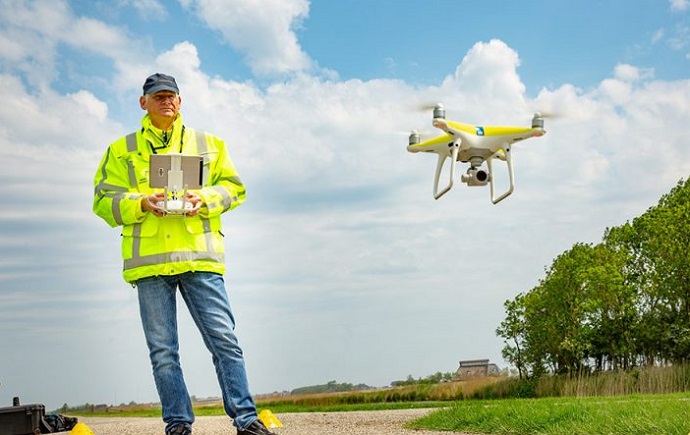
Drone deployment for incident response by Rijkswaterstaat
Drone deployment for incident response by Rijkswaterstaat
 maandag 24 juni 2019
 How does Rijkswaterstaat, in collaboration with partners, design incident response on the water faster and more effectively, using new technologies? This issue has been examined together with partners. A combination of drone technology, data analysis and geomapping has been chosen.
Rijkswaterstaat's ambition is to call in emergency services at the touch of one button and to immediately provide up-to-date information. Huib Kling and Mark de Haan (Aeret) introduced us to the innovative solution. With the help of drone technology, it is now possible to be at the scene of the incident quickly and to take photos immediately. These photos are uploaded by the drone operator to a map (geomapping) that is accessed via the internet and which is available to the supporting services with their Officers of Service. By making this information available en-route, emergency authorities are able to analyze and act earlier before they arrive at the scene of the incident. As a result, damage to people, the environment and equipment can be further prevented and, for example, the fire brigade, police and contractor can be called for assistance.
With a nice demo, an incident report was simulated on the spot of the annual location and the drone pilot and the geomapping expert showed how the information is made available. Unfortunately, due to the turbulent weather it was not possible to fly live with the drone, but that did not detract from the information value of the demo. Rijkswaterstaat has carefully considered which technology or other infrastructure it wants to be in the lead and where it follows other parties. This ensures well-distributed attention and responsibility. For example, according to William Vermeulen, initiator of the innovative Smart Patrol program, a "all weather drone" is being eagerly sought. The developments are going so fast that it is expected that it will come in the near future.
With the use of drones, data analysis, data disclosure and geographical mapping, Rijkswaterstaat and 12 drone operators meanwhile ensure that damage to people and the environment is optimally limited. A reassuring thought.
Kick off sessie CxO’s in de Maritieme sector | Data in het haven-ecosysteem
 19 juli 2024 Kennisdelen op digitaliseringsonderwerpen die relevant zijn in de maritieme sector. Bijeenkomsten worden georganiseerd door/in samenwerking met CIO Platform Nederland en zijn toegankelijk voor organisaties die kennis willen delen over inhoudelijke vraagstukken. lees verder
Even terug kijken op het eerste half jaar van 2024
 12 juli 2024 Een mooie zomerblog van ons nieuwe bestuurslid Edward Cox, tevens Algemeen Directeur Louwman Group Services. Fijne zomer! lees verder
Jaardag 2024, de aftermovie
 08 juli 2024 Een record aantal leden van CIO Platform Nederland kwam op 6 juni bijeen om samen de waardevolle en gezellige Jaardag van onze community te vieren onder de noemer 'Elevate your Digital Transformation'. Bekijk hier de aftermovie. lees verder
Blog: ProRail sponsort de volgende generatie IT’ers
 21 juni 2024 De mini Rubik’s Cube had ik binnen no-time weer opgelost en de doolhof-sleutelhangers waren zo kapot, maar de bèta-Olympiade daarentegen is in mijn herinnering niet stuk te krijgen. Daar ben ik vast de enige niet in. Knik als er nu ook warme herinneringen bij je naar boven komen. lees verder