Drone deployment for incident response by Rijkswaterstaat
Drone deployment for incident response by Rijkswaterstaat
 Monday 24 June 2019
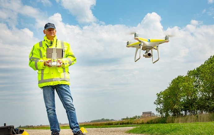
 How does Rijkswaterstaat, in collaboration with partners, design incident response on the water faster and more effectively, using new technologies? This issue has been examined together with partners. A combination of drone technology, data analysis and geomapping has been chosen.
Rijkswaterstaat's ambition is to call in emergency services at the touch of one button and to immediately provide up-to-date information. Huib Kling and Mark de Haan (Aeret) introduced us to the innovative solution. With the help of drone technology, it is now possible to be at the scene of the incident quickly and to take photos immediately. These photos are uploaded by the drone operator to a map (geomapping) that is accessed via the internet and which is available to the supporting services with their Officers of Service. By making this information available en-route, emergency authorities are able to analyze and act earlier before they arrive at the scene of the incident. As a result, damage to people, the environment and equipment can be further prevented and, for example, the fire brigade, police and contractor can be called for assistance.
With a nice demo, an incident report was simulated on the spot of the annual location and the drone pilot and the geomapping expert showed how the information is made available. Unfortunately, due to the turbulent weather it was not possible to fly live with the drone, but that did not detract from the information value of the demo. Rijkswaterstaat has carefully considered which technology or other infrastructure it wants to be in the lead and where it follows other parties. This ensures well-distributed attention and responsibility. For example, according to William Vermeulen, initiator of the innovative Smart Patrol program, a "all weather drone" is being eagerly sought. The developments are going so fast that it is expected that it will come in the near future.
With the use of drones, data analysis, data disclosure and geographical mapping, Rijkswaterstaat and 12 drone operators meanwhile ensure that damage to people and the environment is optimally limited. A reassuring thought.
More news
Kick off session CxOs in the Maritime Sector | Data in the Port Ecosystem
 Friday 19 July 2024 Knowledge sharing on digitization topics relevant to the maritime sector. Meetings are organized by/in cooperation with CIO Platform Netherlands and are open to organizations wishing to share knowledge on substantive issues. CIO Platform Netherlands reserves the right to deny access to meetings. full story
A quick look back at the first six months of 2024
 Friday 12 July 2024 A nice summer blog of our new board member Edward Cox, also General Manager Louwman Group Services. Have a nice summer! full story
Annual Day 2024 - Aftermovie
 Monday 08 July 2024 A record number of CIO Platform Nederland members gathered on June 6th to celebrate our community's valuable and sociable Annual Day together under the banner 'Elevate your Digital Transformation'. Watch the aftermovie here. full story
Research on labour market shortages, help us reach 100 and help yourself!
 Monday 24 June 2024 The shortage of qualified ICT talent is a brake on growth for many organisations. Together with other organisations, we are committed to tackling this challenge. We would like to ask for the help of our members by filling out a survey. full story